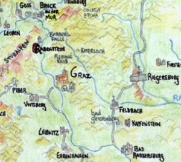
The Mür Valley south to Graz:
The mountains which divide Carinthia from Styria, softly-rounded, heavily wooded, with many practically uninhabited valleys intersperced. A single road cuts across them, from near Piber across the Sallbach River and climbing sharply over the Gaberi pass. On the west side, the Feistrizbach river winds north and into the Mür Valley not far from the Bretsteinbach river. This road is little-used and has fallen into disrepair. It is quite dangerous because of bandits.
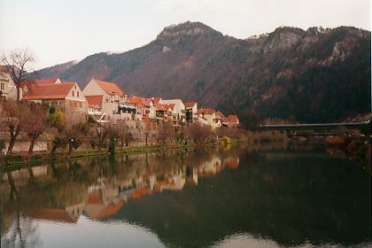
Lies at the confluence of the Mür and the Mürz, 33 miles north of Graz. An unwalled town over which looms the stone fortress of Landskron (on the north bank). The red, white, and red striped flag of Styria flies from its ramparts. Iron mines lie in the surrounding hills. More detailed information is available here.
A great set of raging waterfalls, located in a treacherous gorge just 4 miles north of Rabenstein. The mür is quite impassable before and after this obstacle though, its waters too swift and rocky, and often shallow. Except in the spring, when the river is full from the thawing snows, the boulders around the falls serve as a ford to cross the mür river.
Small village along the Biese river, a tributary to the Mür below. Only two miles north from the Covenant. More detailed information is available here.
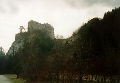
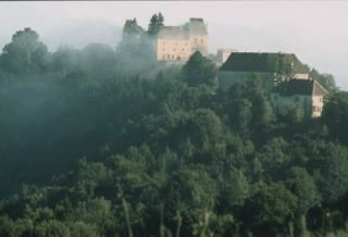
The Covenant and centerpiece of the Saga. A medieval castle built on the ruins of a Roman fort on an abrupt rock jutting out from the Mountains of the Mür River valley north of Graz. Associated with bad luck by the locals, it means 'place of execution', and offers an excellent view of the Valley and the Styrian foothills stretching out to the east.
Located in the southeast along the Imperial border with Hungary, this important town straddles the Mür River, its eastern half huddled against the high bluff which rises 400 feet above the town. A fortress, the Schlossberg, was completed in 1160 and guards the valley. It was formerly the seat of Duke Ottokar of Styria, and houses many of his former ministeriales. Known for its ironworks, the town churns with the steady pounding of watermills which power the forges. Many blacksmiths populate the town.
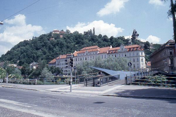
The Schlossberg of Graz
A Cathedral was built in the 12th Century in the Byzantine style, its onion-dome visible throughout the town. Nicholas de Verdun, a master goldsmith and artist lives here. He completed an alterpiece in 1181 with over 50 enameled figures in gold. The town is famous for its fine weapons, and supplies most of the Imperial armies.
Gradetz means castle in Slav, and the military presence is indeed formidible here, the last great town of the Empire before the Hungarian border. Iron mines also dot the mountains and valley nearby. The Teutonic Knights have a house here, and they will construct a Gothic Church with twin-spires from 1202-32. It will contain a beautiful relief of Madonna and Child.
16 miles south of Graz are the ruins of the original Roman settlement of the valley in the Carpathian Mountains. They lie shrouded in the trees now, and date back to 16 B.C., founded by Emporer Vespasian.
Stands adjacent to the site of the Roman town of Flavia Solva. A Roman temple stands overlooking Seggau Castle, which protects the village (though it has been converted to a parish church). The castle belongs to the Bishop of Seckau, though formerly (800-1050) it belonged to the Archbishop of Salzburg. This small town sits on the north bank of the Mür just down river from Graz. A wine road leads to the north toward the steep slopes of the Styrian foothills.
A small village with a fort which houses the Count of Graz's horses, several of which are black coated beauties from Muslim lands. Legends suggest they are descended from an ancient Iberian line from the court of Julius Caesar. Green pastures and rolling meadows characterize the land about Piber, though the dark firs of the Stubalpen loom overhead. A road leads east the 13 miles to Graz, and west across the Stubalpen to Friesach, though this route is made difficult by bandits.
A fortified town along the north bank of the Mür, only 50 miles south of Graz. The Duke of Styria was erecting a castle, called the Ober Radkersburg, before his untimely death, and the Duke of Austria continues the work, which will be completed in 1220. The town church is flanked by an octagonal tower with a bulbous belfry at the town center (the Frauenkirch square). Trees adorn the courtyard along with a statue of the Virgin Mary. Temporarily, an arsenal/garrison is well-stocked with the Duke's knights as this is the last town before the Hungarian border. The hot springs of Bad Gleichenberg lie just 20 miles to the north.
This page last modified 2/8/98.
Comments to madirishman@mad-irishman.net
Return to the Rabenstein home page